Census Indexing Coverage
1851 Census
The map and table below show the coverage of the 1851 Census indexes originally published by the Society as A5 booklets in 1988-99. Each volume contains a historical introduction, a detailed parish/folio number listing, and the index of names. For each individual, the index entry showed Surname, Forename, Age and Folio Number. These census volumes were republished on microfiche, and five of them are now available on CD-Rom.
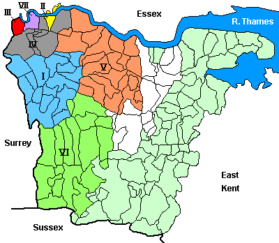
The numbered areas on the above map, refer to the published volume numbers in the table below. The white parishes are covered by the Society's unpublished indexes. The pale green areas are parts of west Kent not indexed by the Society but available from other sources - details are shown in the Society's guide to family history research in west Kent, West Kent Sources (3rd edn. 1998).
| Vol. No. | Title | Piece Numbers | Parish Coverage | Number of Entries |
| (HO107) | ||||
| I | Bromley Registration District | 1606 | Beckenham, Bromley, Chelsfield, Chislehurst, Cudham, Downe, Farnborough, Foots Cray, Hayes, Keston, Knockholt, North Cray, Orpington, St Mary Cray, St Pauls Cray, West Wickham (coloured blue on the map above) | 18,000 |
| Originally published 1988 (114pp.); now available on CD-Rom with linked image pages. More information | ||||
| II | Woolwich | 1588-89 | Woolwich parish (coloured yellow on the map, including north Woolwich, that area of the parish lying north of the Thames) | 32,000 |
| Originally published 1989 (193pp.), no longer available. | ||||
| III | Deptford | 1584-85 | Deptford St Paul & St Nicholas (coloured red on the map) | 32,000 |
| Originally published 1990 (182pp.); now available on CD-Rom with linked image pages. More information | ||||
| IV | Lewisham Registration District | 1590-91 | Charlton, Eltham, Plumstead, Kidbrooke, Lee, Lewisham (coloured grey on the map) | 35,000 |
| Originally published 1992 (206pp.), no longer available. | ||||
| V | Dartford Registration District | 1607 | Ash-next-Ridley, Darenth, Dartford, Eynsford, Farningham, Fawkham, Hartley, Horton Kirby, Kingsdown, Longfield, Lullingstone, Ridley, Southfleet, Stone, Sutton-at-Hone, Swanscombe, Wilmington (coloured salmon pink on the map) | 27,000 |
| Originally published 1993 (151pp.); now available on CD-Rom with linked image pages. More information | ||||
| VI | Sevenoaks Registration District | 1613 | Brasted, Chevening, Chiddingstone, Cowden, Edenbridge, Halstead, Hever, Kemsing, Leigh, Otford, Penshurst, Seal, Sevenoaks, Shoreham, Sundridge, Westerham (coloured green on the map) | 22,000 |
| Originally published 1996 (120pp.); now available on CD-Rom with linked image pages. More information | ||||
| VII | Greenwich Parish | 1586-87 | Greenwich parish (coloured purple on the map) | 35,000 |
| Originally published 1999 (214pp.); now available on CD-Rom with linked image pages. More information |
1861 Census
In the 1990s the Society carried out a limited amount of transcription of 1861, this is available free as part of the Searchable Data section of the website.
1891 Census
Some years ago the Society undertook a full transcription of the 1891 census for a large part of our area under the direction of co-ordinators Brian & May Waymont. The following areas were completed:
| Ref | Title | Piece Numbers (RG12) | Parish Coverage | Number of Entries |
| CD2 | Lewisham Registration District | 516-26 | Eltham, Lee, Lewisham | 93,709 |
| CD14 | Woolwich Registration District | 527-541 | Woolwich, Plumstead, Charlton, Kidbrooke | 107,324 |
| CD3 | Bromley Registration District | 625-34 | Beckenham, Bromley, Chelsfield, Chislehurst, Cudham, Downe, Farnborough, Foots Cray, Hayes, Keston, Knockholt, North Cray, Orpington, St Mary Cray, St Pauls Cray, West Wickham | 69,000 |
| CD16 | Dartford Registration District (Bexley sub-district only) | 635-38 | Bexley, Crayford, Erith, East Wickham | 30,083 |
| CD4 | Dartford Registration District (excludes Bexley sub-district) | 639-44 | Ash-next-Ridley, Darenth, Dartford, Eynsford, Farningham, Fawkham, Hartley, Horton Kirby, Kingsdown, Longfield, Lullingstone, Ridley, Southfleet, Stone, Sutton-at-Hone, Swanscombe, Wilmington | 38,112 |